Five questions for Peter Anthamatten
After exploring a variety of disciplines – German, international affairs, economics and psychology – Peter Anthamatten discovered geography.
“I was always drawn to maps and mapping, and as soon as I started taking classes on mapping and geographic information systems (GIS), I was hooked,” said the associate professor in the Department of Geography and Environmental Sciences at CU Denver. “Geography is defined as the study of places and spaces. Because studying nearly any facet of a place necessarily invokes a broad range of topics, geography is a deeply integrative discipline. I knew that I wanted to work in geography when I discovered the potential to explore problems in this way. While I was attending University of Minnesota for graduate school, I began to see the power of combining spatial analysis with studies of health and so picked up a master’s degree in environmental health.”
Anthamatten works with a “wonderfully diverse array of scholars,” people who study a variety of topics such as climate change, ecology, politics, social narratives, education, air quality, urban studies, forestry, history, and hydrology.
“Our common interest lies in exploring what drives spatial patterns in phenomena across the surface of the earth, the processes that drive the composition of places, and what all that means for how we think about and manage places and spaces,” he said. “As an example of the integrative nature of field: The primary focus of my work has been on how places and locations, such as where you live, affect nutritional and behavioral health. To get at that kind of question in a meaningful way, you must examine a broad range of factors, such as the locations and availability of food sources, the broader structure of the food system and the culture around it, the availability of parks, trails and green spaces, the influence of local crime on your ability to get exercise outside, the social environment, and so forth.”
He has contributed to numerous projects exploring the geographic facets of health, including malnutrition, vaccine efficacy, and obesity. He currently is working on a project with the Latino Policy and Research Center to explore links between asthma severity and the built environment in Colorado.
Anthamatten also has been heavily involved in shared governance since coming to the university in 2008, and currently serves as chair of the CU Denver Faculty Assembly.
1. How has your work surrounding children and physical activity contributed to local communities?
When I came to CU Denver, I immediately recognized that the university has a strong tradition of collaborating with communities in the region and that its scholars pursued research that is meaningful and applicable, and I can identify strongly with those values. My dissertation was on the relation between natural environments and nutrition in Bolivia, and so I sought to realign my work with something more directly applicable to the Denver community.
During my first or second year, I discovered the Learning Landscapes project (see http://www.learninglandscapes.org/), which seeks to serve the children of the city by designing healthy environments. The city of Denver spent $50 million to renovate and improve 96 schoolyards across the city between 2000 and 2012 in close consultation with the program’s director, Lois Brink, a faculty member from the Urban Planning and Landscape Architecture program. Along with the construction, a group called IPLAY (Intervention of Physical Activity in Youth) was studying the health impacts of the renovations. Part of the work involved careful data collection of children’s physical activity on schoolyards in carefully designated “observation zones.”
My role in the project has largely been on the mapping and spatial-analytical facets of the work. As I began to work with the group, I saw the potential to examine how these interventions affected patterns of behavior across the schoolyards. The way the data were collected enabled us to map the data, which could lead to some insights on what kinds of schoolyard designs were the most effective at encouraging health behavior.
The idea behind this work was to provide empirical evidence about the health and behavior impacts of these renovations. Ideally, this could drive some decisions for designers and planners who wish to create healthy, active spaces for children. We incorporated the data into a geographic information systems (GIS), which enabled us to examine maps of activity on the schoolyards and determine if there were parts of the space that were heavily utilized or if children were more active in some parts of the grounds than others.
We found evidence that children responded well to new construction in general, that they responded well to relatively high densities of constructed playground features, and we observed some interesting gender differences. Girls, for example, were more likely than boys to spend time on playground equipment, whereas boys were more likely to exercise in open spaces, such as a football or baseball field. Beyond the implications for construction, this work provides some guidance for how adults could supervise activities during recess to better utilize the schoolyard spaces. I’m currently working with members of the study team to produce some activity maps of the schoolyards and think about additional ways to analyze the data to discern observable impacts of the design on behavior (such as the influence of green spaces or the effects of the type of surface).
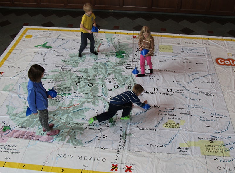
2. Another area of your work focuses on teaching spatial thinking skills to elementary-age children, including a project that uses giant maps. What is the project and why are spatial thinking skills so important?
I spent the final part of my graduate career working on several grants to improve spatial thinking, and I have tried to remain engaged with scholarship in geography around how we teach spatial skills.
Spatial thinking is fundamentally important to many of the topics we study (especially STEM); you need to employ spatial thinking when you study biology, chemistry, astronomy, or just about any type of engineering, for instance. Spatial thought comes into play for a variety of more common, day-to-day tasks as well, such as reading charts and graphs, navigating through town, or assembling Ikea furniture. I believe that spatial thinking is a fundamental skill that human beings are naturally built to learn and become proficient in. Our ancestors must have had a pretty good grasp on navigating their environment at an early age in order to make it into adulthood, and there is lots of evidence in psychology research that shows that children can perform basic spatial thinking tasks from an early age.
Unfortunately, our educational system does not give spatial thinking the same sort of formal treatment that it gives to skills such as reading, writing and mathematics. Much of my work in spatial thinking has revolved around making the case that it is a critical skill that educators should embrace starting in elementary school, and we’ve tried to develop teaching tools that give students practice and experience using spatial thinking skills. The case I, and many of my colleagues, make in our research is that spatial thinking should be actively taught in schools as part of a formal curriculum.
Rebecca Theobald, a geographer in Colorado Springs who worked as the director of the Colorado Geographic Alliance (COGA), introduced me to the giant maps project a few years ago. The National Geographic Society started producing giant vinyl maps for schools to use, and soon thereafter COGA began actively introducing the maps to schools in Colorado. The maps are indeed giant, often requiring a gymnasium to set up and use. The students can then physically walk around on a room-size map and participate in activities to explore the state.
As I joined the project, we began to explore ways that we could use the maps to teach mathematics along with spatial concepts, such as measuring distance, using a coordinate system, and calculating area. In our most recent work, we provide some evidence that fourth-grade students improved performance on these skills after exposure to lessons using the maps. We have submitted a grant proposal to more formally investigate the utility of the giant maps as a tool for teaching spatial skills to elementary-age children.
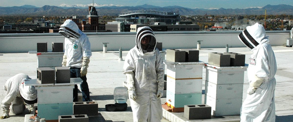
3. What is your role in the CU Denver Bee Project and what are its goals?
The lead on that project is Dr. Christy Briles, a geographer colleague of mine and a palynologist, who initially became involved with bees through her interest in pollen; she studies bees to understand foraging patterns and resource availability for bees in the urban environment. Christy established several research hives around the Denver area — including on the roof of the Student Union building on the CU Denver campus — to facilitate her work. She needed additional beehive sites for data collection, and so I volunteered my back yard when I became interested in the topic and learned about the challenges to the bee population and the promises of urban beekeeping.
The study of urban bees and beekeeping is deeply linked to the environment. The success of bees is driven by factors such as the availability of pollen, nectar and water, as well as exposure to pesticides and parasites (particularly the Varroa mite, which is a significant problem for bees in North America). Since beekeepers are people, bee health is also driven by social factors, such as access to the community, good information and resources for beekeeping.
Maps are one of geography’s key tools for exploring links with the environment, and so I started working with Christy to develop maps of beekeeping activity and health. We collected over 200 surveys from beekeepers in and around Denver, who gave us an approximate location of beehives across the city, with keeper-provided information about their health. With these data, we are trying to produce maps of beekeeping activity, and hope to use the data to test for systematic patterns in problems for bees (such as hive death or Varroa mite infestations) to explore links between environmental factors, beekeeping success, and bee health. We are presently working through some challenges with the data, but we have observed that beekeeping occurs in wealthier parts of the city. (For more information, see https://www.cudenvertoday.org/cu-denver-researchers-abuzz-bee-health/)
4. How long have you been involved with the CU Denver Faculty Assembly and what are your goals, both personally and as chair of the organization?
I became involved with faculty governance when I began working at CU Denver by serving on different college and university committees. I began to serve as a College of Liberal Arts and Sciences representative to the Faculty Assembly several years ago and began my position as chair of the CU Denver Faculty Assembly in fall 2017.
I have become convinced that shared governance is extremely important to maintaining a vibrant and robust university community. While administration, faculty, staff and students have an awful lot on our plates to begin with — and there are often frustrating challenges to running such a massive and important organization as our university — shared governance is critical for helping the entire university community to understand the goals and challenges of all its members.
In a general sense, my charge and goal as chair of the Faculty Assembly is to ensure that the faculty have a strong voice with respect to university governance. A broad and long-standing university tradition, codified in the CU Regent Laws and Policies, that the faculty “takes the lead in decisions concerning selection of faculty, educational policy related to teaching, curriculum, research, academic ethics, and other academic matters.” (See Article V of the Regent Laws, https://www.cu.edu/regents/laws-and-policies/regent-laws/article-5-faculty). Since faculty are the ones who develop and deliver curriculum, mentor students, drive research, and who often work directly with Colorado community, our voice is important!
The Faculty Assembly has engaged with a range of issues over the last couple of years. Often working in collaboration with the Faculty Council (the systemwide governance body), examples of recent activities of CU Denver Faculty Assembly include:
- providing input to the revised budget model
- responding to proposed revisions to the Regent laws
- establishing the CU Denver Curriculum Committee (which monitors for course duplication campus wide)
- advising revisions to the Faculty Course Questionnaires
- working with administration to develop a student grade forgiveness policy
- monitoring the treatment of students protected by the Deferred Act of Childhood Arrival (DACA)
- monitoring proposed university policies that pertain to faculty business
- providing feedback about policies and decisions around educational technology
This year, our recent foci have included articulating our perspective on the Regents’ civics education initiative, contributing to the search for a new CU president, and reviewing CU Denver policies pertinent to women’s issues and access for disabled members of the university.
One thing I would really like to emphasize is that faculty governance is a massive endeavor that takes a huge amount of work and dedication from faculty across campus. The Faculty Assembly alone contains 45 voting members and manages eight separate subcommittees to address specific facets of university governance. My role as Faculty Assembly chair has given me the opportunity to work with people spanning the entire campus, and that has given me a sense for both the vibrancy and complexity of the CU Denver community in a way that I had not experienced before.
I’m finishing my term as Faculty Assembly chair as I gear up to chair the Department of Geography and Environmental Science (GES) starting in the fall. Working with different kinds of faculty governance has kept me on my toes.
5. What hobbies or leisure activities do you enjoy outside of work?
Like a lot of geographers, one of the reasons I was initially driven toward the field was out of a love for exploring other places and I am always looking for excuses to travel, especially if I can manage to travel abroad.
I have always been fascinated by languages and I like to think of myself as bit of a hobby linguist.
Over the last few years, I have come to adore carpentry and look forward to having the time to build something when I have a good project going. It’s amazing what you can learn to build with a few good tools. I also love to cook very spicy vegetarian food.
I share an enthusiasm for board games with my two teenage daughters and we work together to explore a huge variety of them. I have a long-standing passion for a couple of classics: chess and tournament-style Texas Hold ’em poker. Both are deeply nuanced games that you can study for decades and not come close to mastering.